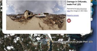
Google has made an interesting addition to the photos layer in Google Earth. Users will now be able to view panoramic photos of the areas affected by the recent earthquake and tsunami that hit Japan.
With a lot of work on the recovery process still ahead, it's important to keep the world informed and the tragedy in the public eye to encourage more people to help in whatever way possible.
"In an effort to continue to help keep people informed about the extent of the tragedy that has recently struck Japan, Google Earth has added panorama photos of post-earthquake zones," Wei Luo, technical lead/manager, Google Earth, announced.
"These photos come from our partner 360cities and can be found in the 'Photos' layer in Google Earth, along with other 360cities and Panoramio photos. These dramatic panorama photos are part of the work of photographer, Akila Ninomiya," he explained.
Google recently started adding panoramic photos from the dedicated site 360cities. Like Google-owned Panoramio, the focus is on geo-tagged imagery, but the photographers showcasing their works on 360cities specialize in 360 degree, panoramic photos.
"In March 2011, Mr. Ninomiya took his camera and bravely ventured into the heart of post-earthquake zones in Iwate Prefecture, Japan. He documented earthquake and tsunami damages in cities including Rikuzen-Takada, Kamaishi, Osawa, Miyako, Settai, and Omoto," Google added.
You can check out the works in Google Earth, as long as you have the Photos layer enabled. Visiting any of the cities listed above, you'll notice some photos have an orange border, indicating that they are panoramic.
Clicking on any of them will reveal a photos pop-up with a preview of the photo. Click on that and you'll be able to see the panoramic photo and explore the different perspectives. Google is also providing a KML file which showcases the panoramic photos related to the devastation in Japan.

 14 DAY TRIAL //