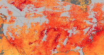
In a recent study, experts at the American space agency compiled a new map showing the concentration of the dangerous greenhouse gas carbon monoxide (CO) above the United States and Canada.
The dataset paints a very alarming image, indicating massive concentrations of the stuff above most areas. In the attached view, the redder portions are those with the highest concentrations of the stuff.
Only a few regions, in the Pacific Northwest, Florida, and some segments of the eastern portion of the country exhibit lower CO concentrations. The new map was created using readings gathered by the Measurements of Pollution in the Troposphere (MOPITT) sensor on the NASA Terra satellite.
The situation was worst on June 8, when a thick haze was covering the United States from the Midwest to the East Coast. The air people breathed from these gray skies was a very poor quality, experts say.
They add that the Wallow Fire was one of the lead causes for the haze, but say that other sources were at work as well. High temperatures and calm winds allowed the pollution to spread over central and eastern regions of the US and southern Canada.
Terra's readings were collected between May 25 and June 8, and they clearly show the influence that wildfires have in releasing CO. Generally, in the US, open fires are the third source of carbon dioxide, after gasoline-burning cars and other vehicles.
“A second source of carbon monoxide is Alberta, Canada, where large wildfires are burning. A forecast from the GEOS-5 model shows carbon monoxide from both fires moving east and converging over the eastern United States,” experts with the NASA Earth Observatory say.
“Carbon monoxide measurements from the AIRS instrument on the Aqua satellite also track smoke moving east between June 3 and June 6,” they add in a statement issued to the press.
Finally, some of the CO in the new map comes straight from the Atlantic Seaboard itself, where the huge American megalopolis is located. Urban pollution is one of the most important sources of carbon monoxide in the world.
“In high concentrations, carbon monoxide can harm human health by reducing oxygen to the heart and brain. Carbon monoxide is also one of the chemicals that create ozone pollution and urban smog,” the press release adds.
“Poor air quality continued to plague the eastern United States on June 9, when the air was expected to be unhealthy for sensitive groups in more than 80 cities, triggering air quality action days in 49 locations,” Earth Observatory experts conclude.

 14 DAY TRIAL //