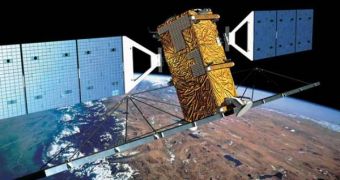
Canada's territorial waters are, at times, safe havens for illegal fishermen, who venture in their small boats off the coasts, and make a dent in the fish population, either by harvesting more than they need, or by doing so during the reproductive season. But surveying such a huge coastline as the country's is no easy task, and that's why authorities have long since turned to satellites, in a bid to curb infractions in waters off their coastlines.
With the deployment of the Radarsat 2 satellite, collecting pieces of evidence about suspicious boats has become a lot easier, and authorities have registered a spike in the efficiency of their actions against illegal activities. Now, because of the tremendous success that the eye-in-the-sky has brought forth, the Canadian space agency is considering extending its operational maritime surveillance capabilities with a new generation of similar (but better) satellites, which has been dubbed the Radarsat Constellation. Each observatory in the group will be outfitted with an Automated Identification System (AIS) terminal.
Colonel Francois Malo, a representative of Canada's Department of National Defense, said that the effort would be deployed in parallel to an already existing one, conducted by the Com Dev International, of Cambridge, Ontario. The enterprise has already built a number of small satellites equipped with the AIS system, which it says to be ready to deploy. The technology was successfully tested in April 2008, when the first observatory of the series was launched and turned on.
Speaking at the SMi Group-organized Milspace 2009 conference, Malo presented the facts fairly simple. Canada has a 243,770-kilometer-long coastline, about 250 ports alongside it, and a ship traffic volume of 1,700 per day. Under these circumstances, the standard CP 140 maritime patrol aircraft that Canadian authorities use needs to fly for 180 hours to confirm illegal activities, at a cost of 27,000 Canadian dollars ($22,330) per hour.
He added that, by using high-resolution satellite images, a suspicious ship was spotted from orbit, and that the airplane gathered sufficient pieces of evidence within six hours, saving a lot of money. Basically, he shared, satellite images would be used to determine the activity of which ship deserved an overhead pass with the airplane, for direct observations. This would eliminate the inefficient approach that flying the aircraft non-stop constitutes, Space reports.

 14 DAY TRIAL //