14 DAY TRIAL //
 A protected area with multiple functions, Camargue Regional Park was created in 1970, in the department Bouches du Rhone, for protecting various bird species, wetland ecosystems and to find viable methods of exploiting the natural resources without degrading it. In 1990, the 85,000 hectares of the park were labeled as "Biosphere Reserve" by UNESCO, being a model of how humans can cohabit with wildlife.
The park generally overlaps the Rhone Delta, presenting two distinct sectors: Grande Camargue, at the mouth of Rhone, between its two arms - Grande Rhone and Petite Rhone - and Camargue Gardoise, west of Petite Rhone.
Camargue is the result of the Rhone-Mediterranean interaction and, in time, its shape has changed. Camargue looks like an island whose edges are marked by waters in the Gulf of the Saints Maries. It is an area of sun (more than 2500 hours of intense sunlight annually), winds and waters, made of millions of tons of deposits carried by Rhone, and of banks, solid ground, lagoons, roads, dams, households and crops. In the south, the Mediterranean Sea's shore currents formed compact sand dunes, disposed on a line, like an Arch. Along the centuries, people fought to reduce the effect of the flooding caused by the river and, on the other hand, of the intrusion of salty sea water.
At the end of the 19th century, both the sea and the river were under the control of the local communities, which practiced an intensive agriculture. The building of the dam, in 1859, was determined by the exploitation of the sea salt and led to the creation of an ample complex known as Salins de Giraud. In 1860, Rhone was dammed to limit the freshets flooding the arable terrains, causing huge damages. At a given moment, the inhabitants cultivated irrigated vineyards, but after the WWII, the intensive culture of the rice significantly decreased the area of wild ecosystems.
Ample projects led to the increase of the net of irrigation ditches, which allowed the desalinizing of some lands and hydraulic workings that satisfy the need of freshwater of the 20,500 cultivated hectares.
But the dams impeded the natural supply of sediments and freshwater. The high number of canals, pumping stations and ditches shows that the myth of the wild Camargue is no longer a reality.
Camargue harbors a high number of fragile wet ecosystems. Sloughs and swamps make most of the Rhone Delta. They are 20-80 cm (0.6-2.6 ft) deep and have seasonal fluctuations. The delta is a refuge both for migratory birds and sedentary birds. In 1927, the ornithological zone Pont du Grau was created, on an area of 13,117 ha. Buoying paths allows the visitors to see the protected and rarely viewed bird species, from egrets to wild ducks, bitterns, herons, stilts, wagtails and sandpipers.
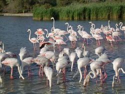
The bird reserve Etang de Vaccares has 6,000 pools, being the largest in the Rhone Delta. With depths mostly under 2 m (6.6 ft), this aquatic zone is influenced in quality by the 50 million cubic meters of waters representing the draining from the rice paddies located to the north. This is the preferred biotope of mallards, coots, gulls, terns and grebes. But the bird that stands out as the symbol of the area is the flamingo, a bird whose name comes from Latin "flamma" (flame), alluding to the fact that, under the pink feathers, there is another layer of coral-red or bright-red feathers.
This is the only region in Europe, together with 1-2 Spanish sites, where flamingos nest. The flamingo population of Camargue is of about 20,000 pairs, breeding in colonies strictly observed by human guardians. The flamingo nests are made of mud raised over the ground level.
At the contact with the Mediterranean, there is the "dam area", with a length of 20 km (12 mi), where the circulation of the cars is strictly forbidden. It is a heaven for the birds, from gulls to terns and avocets.
In the west, after the Gacholle Lighthouse, there is a sector of semimobile and mobile dunes, often protected by chestnut palisades that fix the sand. Specific dune vegetation - including spurges, sand iris, quitch grass and others - is commonly found here.
Many low terrains of Camargue are covered by a salt crust, and here, a halophile (salt loving) vegetation grows, like glasswort (Salicornia) and saltwort (Salsola), which bulls and feral horses feed on. These terrains are flooded in the winter, and offer food for the wader birds in the spring. Along the arms of the Rhone and on the old dunes, south of Vaccares, there are many forested spaces. They may occupy small surfaces, but they are important in maintaining the delicate balance of the park. This is the favorite biotope for wild boars, foxes, rodents and many insects.
Salty lagoons are surrounded by dunes. Today they are strongly modified by man, salt extraction being one of the most important activities in Camargue. The evaporation basins of Salin de Giraud occupy 14,000 ha, producing on average 1,000,000 tons of salt annually (one of the largest productions in Europe), in an extraction cycle in 4 phases: bringing the sea water into the basins, salt concentration through natural evaporation, salt deposition and drying, and the harvesting.
The Camargue households are built with thick walls, offering cooling during the summer and resisting to the violent mistral wind, descending along the Rhone, during the winter.
The entrance to Camargue is made through the city of Arles (52,593 inhabitants), founded by Caesar in 46 BC, and still harboring Roman vestiges (amphitheater and forum). In Saint Maries de la Mer, a small village in the southeastern part of Pont du Grau, over an ancient Gallo-Roman sanctuary, a fortified church was built in the 10th century. The church harbors relics of two Saint Maries - Saint Mary Salome, and Mary, the sister of the Virgin, come into the area for spreading Christianity after the death of Jesus. The church also contains the statue of their Egyptian servant, Sara, considered the patron of the Gypsies by more than a century. A traditional festivity is hold in the honor of these saints on 24th of May every year. These festivities bring 8,000 gypsies in the area annually.
Amazingly, even if modified by human activity, the geometry of Camargue, with its salt fields and rice paddies, does not diminish the beauty of nature. These people learned to combine harmoniously the resource exploitation and biodiversity conservation.