Figuring out exactly how drought affects a particular area can be rather difficult from the ground, and even from aboard aircraft or satellites. However, these phenomena reveal all of their secretes to Moderate Resolution Imaging Spectroradiometer-class (MODIS) instruments.
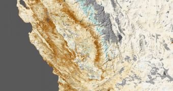
The NASA Terra and Aqua satellites both feature MODIS instruments, and the space agency has recently used data from the two spacecraft to create a composite image showing the vegetation cover throughout the state of California. Brown colors are used to show areas with decreased vegetation, while greener hues indicate more plants than the average.
As we can clearly see above, more vegetation can currently be found on mountain peaks, which is very bad. These mountaintops should have been covered with ice at this point, ensuring that continuity of water supplies for the state in the spring. As it stands, water rationalization may have to be kept in place for longer.
The photo shows the state of Californian vegetation at the end of January. NASA will continue to analyze its state continuously as the two satellites fly overhead. The take-away message from this composite view is that most of the state seems to have experienced a massive decrease in the amount of vegetation available.

 14 DAY TRIAL //