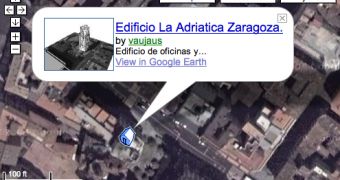
Google introduced one more feature concerning the products powered by the company: SketchUp, Maps and Earth. If you want to develop your own city for Google Earth and you upload it on the 3D Warehouse page, you can now view it straight on a Google Map using the Maps View function. Basically, all your creations for a certain location in Google Maps/Google Earth are now available in a separate view through the new function. All you need to do is to open your collection from 3D Warehouse and click on a certain model. The new feature will be automatically started and you should be able to see a Google Map containing your own 3D buildings.
"The Maps View feature helps you navigate through all the geo-referenced models in your collection. When you go to the main page for your collection, you'll see a Google Maps view of your collection items. Using this map you can monitor your progress. (Is the neighborhood crowded enough for you?) You can also navigate the entire collection without paging through the hundreds of models you've gathered," Mark Limber, Product Manager, sustained today.
As you can see in the picture attached to the article, the new function is an excellent comparison tool because it allows you to observe the differences between the real building and your own 3D creation. The Maps View also enables the users to view the location in Google Earth, an interoperability that was first introduced a few days ago when the downloadable application was improved with Maps compatibility. If you didn't know, Google quietly released a new version of Google Earth, the 4.1 beta release bringing several new features. For example, you're now able to view a certain Google Earth location straight in the web-browser by pressing the Google Maps button.

 14 DAY TRIAL //