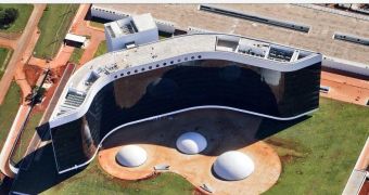
There are plenty of ways to explore the world in Google Maps, but a fun one, where available, is the 45 degree mode. In cities where Google has managed to get a hold of aerial imagery, it makes for a much more detailed view and it's also more useful as a guide than top-down satellite imagery.
Not to mention, it enables users to check out famous locations around the world, or their childhood home, from a bird's eye perspective.
Google has updated or added new 45-degree imagery for 21 places, mostly in the US. But there's a very special city on the list as well, Brazil's capital, Brasilia.
Brasilia has got quite a history, not in the sense that it's long, but in the sense that it's interesting. It was built from scratch from 1956 to 1960, when it became the capital, fulfilling an idea more than a century old at that time.
The city was designed by Lúcio Costa and was very carefully laid out from the get go. Its unique architecture and clearly visible urban plan make it quite a sight to be seen, especially from high above, where the original layout looks like an airplane or a bird.
It is now home to all of the Brazilian administrative buildings, 119 embassies and the headquarters of many large companies.
Still, most of the images in the update are from the US. Google's headquarters, the Googleplex has new imagery, but there are also new photos for Las Vegas and even Boulder, Colorado.
Several cities in the US are included in this latest 45 degree imagery update Albuquerque (west), NM; Benton, AR; Boulder, CO; Eldridge, IA; Boston (east), MA; Centennial (south), CO; GooglePlex, CA; Indianapolis (south), IN; Las Vegas Strip, NV; Montgomery (outskirts), AL; Olathe, KA; Petaluma, CA; Tulsa, OK.

 14 DAY TRIAL //