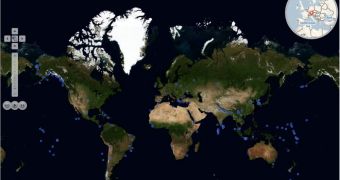
Bing Maps World Tour is a new tool introduced by Microsoft following the rebranding of Live Search Maps to Bing Maps and Virtual Earth to Bing Maps for Enterprise. The tool is designed to allow end users to keep up with the changes introduced to Microsoft’s mapping, location and search platform each month. The Redmond company has made it somewhat of a tradition to update the imagery of Bing Maps, formerly Live Search Maps/Virtual Earth on a monthly basis, delivering multi-TB refreshes. In this sense, Bing Maps World Tour is set up to highlight the monthly makeovers of Bing Maps.
“The Bing Maps World Tour is a rich new way of viewing our imagery updates every month by navigating the respective pins or just watching the slide show take you around the world to explore the new imagery. I’ve provided a detailed description of the application’s features below so you can fully appreciate the experience of exploring our imagery, photography and road data updates,” explained Chris Pendleton, the Virtual Earth technical evangelist for Microsoft.
Pendleton revealed that with the latest imagery update to Bing Maps Microsoft had its platform covering no less than 248,000+ square kilometers of territory. For the Bing Maps World Tour tool, the Redmond company has gone with an interface built in Silverlight. The software giant leveraged the Bing Maps Silverlight Control, a Community Technology Preview for the time being. In addition to Silverlight, Bing Maps World Tour takes advantage of the company's Cloud operating system: Windows Azure.
“We’ve gone out of our way to further showcase our investments in imagery and photography by building out the Bing Maps World Tour – an application meant to allow for full exploration and appreciation of the data we’re publishing every month on Bing Maps,” Pendleton added.
Users will be able to control their experience when using Bing Maps World Tour with the help of a few options made available by default. In this regard, Microsoft is allowing for slideshows of the monthly imagery updates to Bing Maps to be controlled, paused, fast forwarded, etc. Filter Release Data, Zoom to World Map, Share Map, Show Fullscreen, Map Style and Map Help are additional options that can be enjoyed for a deeper experience.
“Slide Show – Sit back and watch the slide show as it bounces through each region that has been included in the release,” Pendleton said. “Explore! – Explore the map on your own. Zoom out, zoom in, enjoy multi-image scaling greatness and click on icons to discover the new imagery. Navigation Bar – A hyped up navigation bar provides for easy zooming and panning to a specific location, but also buttons to rewind, play, pause and fast forward the slideshow. Inset Map – Using a second instance of the Bing Maps Silverlight Control drawn in an ellipse makes for easily getting your bearings as to where in the world you are.”

 14 DAY TRIAL //