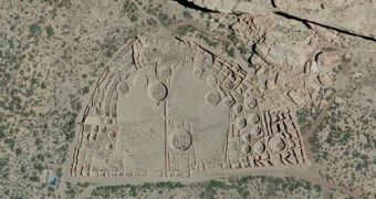
Bing Maps just got a lot more detailed. To be exact, aerial images in the US are now incredibly detailed across the country. Microsoft is boasting that Bing Maps now has images at 30cm resolution, i.e. 1 pixel represents a 30x30cm square or a square foot.
That's not the highest resolution available in commercial map products, but Bing is now the only one to offer it for every corner of continental US.
From coast to coast, from the Mexico border all the way up to Canada, every inch has been photographed and is available in amazing detail.
That means that there's no place you can think of that you can't visit, check out your home from above, or the place you grew up in, or any famous but remote landmark. Well, actually, there are two places that you can't see in such great detail.
The first is Area 51, which is by now as secret as the Statue of Liberty, and the Vandenberg Air Force Base in California.
"The effort to bring high resolution imagery to market began in 2006 when Microsoft entered the aerial photography business with the acquisition of Vexcel Imaging. Microsoft began evolving and improving the flagship UltraCam aerial camera, and over time, developed a special version of the camera that acquires a very wide swath of imagery at high resolution," Microsoft wrote.
"With this new camera Microsoft conceived the Global Ortho project, designed to bring consistent quality and resolution to every part of the United States and beyond," it said.
The Bing team has now concluded gathering the imagery for the US – it took two years. But the new data is not live yet; it's still being processed and stitched together and will eventually make its way into Bing Maps. The next phase of the program is to cover Western Europe at the same detail level.

 14 DAY TRIAL //