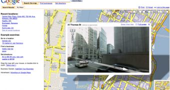
The Mountain View company Google introduced an awesome function for Google Maps, the online service that allows you to view maps and satellite imagery. Basically, the new feature, codenamed Street View, gets you straight on the street and offers you an amazing view. At this time, you can get 360-degree panoramas only from 5 cities: San Francisco, New York, Las Vegas, Miami and Denver. All you need to do is click on the "Street View" button placed near the "Traffic" tab and move a little yellow figure on the street you want to view. Depending on your Internet connection, Google Maps will load high-resolution photos and will allow you to rotate the picture and view 360-degree panoramas.
"I'm proud to announce that today we are launching a new feature that will further enhance your ability to understand the world through images -- Google Maps Street View. With Street View, you can virtually explore city neighborhoods by viewing and navigating within 360-degree scenes of street-level imagery. It feels as if you're walking down the street!" Stephen Chau, Product Manager at Google, said today.
Obviously, this is a major update for Google Maps because it offers a different perspective over the high-resolutions photos included in it. Until now, the parent company Google struggled to enable users to view maps and 3D imagery by requiring users to create their own drawings with Google SketchUp. This update is really explaining a lot of things: remember the detailed photographs captured by Google's employees on the Australian Day? At that time, the search giant's employees wanted to fly at a 600-meter altitude and take photos for both Google Earth and Google Maps. Maybe Australia will also receive this major update soon although we're all waiting for the implementation of Street View in Google Earth.

 14 DAY TRIAL //