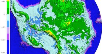
An international collaboration of researchers announces the creation of the most comprehensive map to date depicting the Aurora Subglacial Basin. This is one of the least investigated regions of the world.
Very few charting expeditions have ever been conducted in these treacherous waters, the experts behind the new work say. They add that the first, high-resolution topographic map of this region was produced in East Antarctica.
The ASB is an extremely-large lowland, that is more widespread than the entire state of Texas. While conducting the mapping effort in this region, experts found the largest fjords in the entire world.
Fjords are channels cut through the land by moving ices. They can be seen adorning the costs of Norway, and are a trademark for the North European country. Scientists say that the discovery made in Antarctica should give them a better insight into the continent's history.
According to investigators, this work will give climate scientists more data to include in their models. The topography of the land beneath the East Antarctic Ice Sheet (EAIS) bears a direct influence on the way in which glaciers above flow towards the Southern Ocean.
With the new discoveries included in their datasets, computer models may become more accurate in predicting the potential impact that ices in East Antarctica will have on global sea levels. Most of the world's ice masses are located in Antarctica, Greenland and the Canadian Arctic.
As such, studying these areas from every possible angle could have a significant implication on the way we understand global warming, and the climate change it is causing. The particularities of each ice “reservoir” need to be thoroughly understood, experts say
One of the most interesting things about the ASB is that it lies a few kilometers below sea level. What this means is that water could easily penetrate deep underneath the ice, destabilizing ice banks.
Usually, this leads to massive chunks of ice falling apart from the banks, and floating off to sea. Further details of the work appear in the June 2 issue of the top journal Nature. The lead author of the work was Duncan Young, a University of Texas in Austin Institute for Geophysics research scientist.
The research was conducted using funds provided by NASA, the US National Science Foundation (NSF), the UTA Jackson School of Geosciences and the Antarctic Climate and Ecosystems CRC, of Australia, among others.

 14 DAY TRIAL //