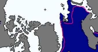
According to the latest report from the US National Snow and Ice Data Center (NSIDC), this winter exhibited a series of particularities, especially in terms of the vast differences between temperature levels in the Arctic and over the United States. The Center reports that winter ice covers at the North Pole grew slower this season than in previous years.
At the same time, the eastern half of North America was battered by extremely-low temperatures, brought on mainly by the polar vortex that again shifted its position and allowed cold winds to escape over the United States and Canada. Meanwhile, in the Arctic, temperatures have remained constantly above average for this period.
It is due to these warm conditions that sea ice growth has stagnated over the winter, experts argue. Relatively speaking, the Arctic Ocean is warmer than the ice packs above, so the lack of sea ice also allowed for more heat to be transferred into the atmosphere, heating up Arctic air even more.
If previous trends persist, this month should see the North Pole achieving its maximum sea ice extent of the year. According to predictions, these values will remain below average, reflecting similar measurements collected over the past decade or so.
Statistics for the month of February reveal a sea ice extent covering 14.44 million square kilometers, or 5.58 million square miles, some 910,000 square kilometers (350,000 square miles) below the 1981-2010 average. This means that last month was the fourth-lowest February in the satellite record.
Throughout last month, sea ice extents grew at a slow rate, of just 14,900 square kilometers (5,750 square miles) per day, around 25 percent slower than the long-term average. The Bering, Barents, and Okhotsk seas all displayed sub-average ice extents, leading the entire Arctic to keep ice amounts two standard deviations below the average.
“The Barents Sea has experienced consistently low extents, particularly in winter, and this year has been no different. While the Barents and Kara seas normally have close to 2 million square kilometers (772,000 square miles) of ice in February, recent years have seen 500,000 square kilometers (193,000 square miles) of ice extent or lower,” the team explains in its report.
Daily ice accumulation values are expected to be even lower this month, as the maximum extent draws nearer. According to NSIDC investigators, the Arctic remains within a medium-term trend of losing about 46,100 square kilometers (17,800 square miles) every February.
Average air temperatures in the central regions of the Arctic oscillated between -25 to -15 degrees Celsius (-13 to 5 degrees Fahrenheit). These values are outside of the usual range for the month of February. Anomalies range from 4 to 8 degrees Celsius (7 to 14 degrees Fahrenheit) above the average.

 14 DAY TRIAL //