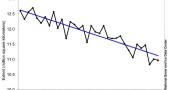
Officials with the US National Snow and Ice Data Center (NSIDC) say that the month of June saw extensive sea ice melting patterns throughout the Northern Hemisphere, and particularly in the Arctic.
Sea-based ices were a lot less spread in June compared to previous years, and this is just a continuation of a trend that has been going on for at least six years. Record daily lows were established last month on several instances, a new report from the Center explains.
Ice loss was extensive throughout both May and June, and will most likely continue this month as well. However, we won't know for sure whether that's the case until the data are centralized, in early August.
According to the newly published report, severe ice loss affected the Kara Sea, Bering Sea, Beaufort Sea, the Hudson Bay and the Baffin Bay. Overall, the general trend for the ice was to retreat a lot faster than seen in previous years.
Scientists believe that the recent trend of rapid spring snow melt is largely responsible for this situation. In June, Arctic sea ice extents averaged 10.97 million square kilometers (4.24 million square miles).
This level is around 1.18 million square kilometers (456,000 square miles) below the average level recorded between 1979 (when satellite records of the Arctic began being kept) and 2000.
Official NSIDC statistics indicate that June 2010, June 2011, and June 2012 saw the three lowest ice extents ever recorded via satellite. This year's June level came within 140,000 square kilometers (54,000 square miles) of the record low set in 2010.
The report indicates that the only location in the Arctic where sea ice levels are above average levels is along the eastern coasts of Greenland. However, this positive effect is counterbalanced by the fact that the currently-recorded extent decline occurred 3 weeks ahead of schedule.
Based on analysis of the 1979-2000 interval, experts were not expecting to see the June 30 ice extent – around 9.59 million square kilometers (3.70 million square miles – until at least July 21. This means that the ice is melting in greater quantities, and at accelerated paces, which is in tune with predictions.
“Prior to the onset of melt, the ice was thicker than observed in recent years – around 1.8 meters (5.9 feet) as compared to typical conditions of around 1.4 meters (4.6 feet),” the NSIDC report states.
“Despite this thick ice at the beginning of the season, melt proceeded relatively rapidly. Melt ponds began forming on June 4 – a typical timing for recent years, but high temperatures, sunny afternoons, and foggy nights combined to speed the melt of ice thereafter,” the document concludes.

 14 DAY TRIAL //