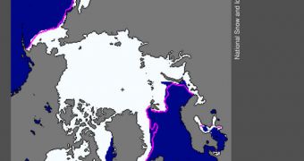
Throughout the month of January, the Arctic Oscillation has been holding steady in its strong negative phase, which influenced the extent of sea-based ice at and around the North Pole considerably. This event caused experts to record the lowest such extent in recorded history last month.
Climate experts began keeping track of ice extent in the Arctic in 1979, when the first satellites dedicated to weather observation were launched by the United States. Since then, there has never been as little ice at the North Pole as there is today.
In January 2011, the average ice extent was 13.55 million square kilometers (5.23 million square miles), which is some 1.27 million square kilometers below the 1979 – 2000 average. The second-lowest extent on record was 13.60 million square kilometers, set in 2006.
There were several key factors that contributed to this phenomenon, including global warming, climate change, the Arctic Oscillation, changing precipitation patterns due to the La Nina atmospheric event of the tropical Pacific and so on.
All these influences conspired to reduce the amount of available ice drastically, while at the same time allowing the trend of melting multi-year ice to continue. This is very worrying, since it takes about a decade or so of cold temperatures for this type of ice to establish itself.
Usually, by late November, areas such as the Hudson Bay, the Hudson Strait and the Davis Strait freeze over, but this year that didn't happen. All these regions were unusually devoid of ice for this time of the year.
It was only in mid-January that the Hudson Bay become totally covered in ice, a phenomenon that speaks volumes about how climate patterns are changing in the Arctic. At this time, the Labrador sea is covered in ice only at certain location, but remains largely free.
A report released by the National Snow and Ice Data Center (NSIDC) indicates that air temperature have stabilized at levels 2 to 6 degrees Celsius (4 to 11 degrees Fahrenheit) above average.
These warm temperatures are caused by the unfrozen ocean, which releases stored heat continuously, and by Arctic Oscillation-induced wind patterns. This caused a linear rate of decline for January to reach –3.3percent per decade.
“Some scientists have speculated that more frequent episodes of a negative Arctic Oscillation, and the stormy winters that result, are linked to the loss of sea ice in the Arctic,” a NSIDC statement says.
“Judah Cohen […] and his colleagues propose another idea – a potential relationship between early snowfall in northern Siberia, a negative phase of the Arctic Oscillation, and more extreme winters elsewhere in the Northern Hemisphere,” the statement adds.
“More research on these ideas may shed light on the connections and have the potential to improve seasonal weather forecasting,” the document concludes.

 14 DAY TRIAL //