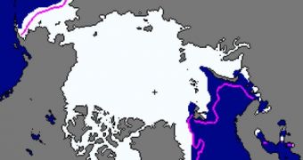
US National Snow and Ice Data Center (NSIDC) investigators say that Arctic sea ice extents were below average this January, for the most part. Some areas did display increased ice concentrations – which exceeded normal values for this period – such as the Bering Sea.
Keeping track of how ice forms and melts in the Arctic is an extremely important objective, because these phenomena have the capacity to influence global climate patterns. They can dictate how oceanic currents flow, the severity of any given winter and other such aspects.
Water that results from the melting of glaciers, for example, is significantly darker than regular seawater, which means that it absorbs more sunlight and heat. This in turn heats up glaciers from underneath, forcing even more water to melt; and the cycle begins anew.
NSIDC is compiling statistical analyses of the Arctic for each month. For January, sea ices were found to be less extensive than the average, except for the Bering Sea, where more ice than experts had expected formed last month.
The direction of ice movements also changed, once the Arctic Oscillation turned negative. The AO was positive throughout November and December, which helps explain why weather in Europe was so dry and warm during the first two months of winter.
Now that the AO is negative, cold air masses that were previously trapped in the upper atmosphere are now flowing above Europe, bringing about numerous blizzards, snowstorms and extremely cold weather. More than 450 people have died in the European Union due to the extreme cold.
According to satellite data, Arctic sea ices reached the fourth-lowest extent on satellite record, about 13.73 million square kilometers (5.30 million square miles). This is about 1.10 million square kilometers (425,000 square miles) below the average value, set between 1979 and 2000.
Even if the Bering Sea was nearly covered in ice – on the Pacific side of the Arctic – it could not compensate for the extremely low ice extents present on the Atlantic side. This is why, overall, Arctic ice extents were well below average last month.
Climate scientists have been warning that variations such as this would take place if global warming went unchecked. Their long-term predictions are now coming true. “The growth rate for Arctic sea ice in January was the slowest in the satellite record,” the NSIDC report explains.
“After growing relatively quickly early in January, ice extent declined briefly in the middle of the month, and then grew more slowly than normal for the rest of the month,” the document concludes.

 14 DAY TRIAL //