According to the latest monthly report released by the US National Snow and Ice Data Center (NSIDC), it would seem that the sea ice extents recorded in the Arctic were the third lowest on record.
The values indicated that the extents were the third lowest since satellite data monitoring began in the area, back in 1979. The new statistics confirm that Arctic ices are continuing the long-term decline.
The effect is brought on by global warming and the climate change it triggers. Several feedback loops have already been produced in the area, including one that sees more ice melting on account of the fact that melting ices are causing the waters to darken.
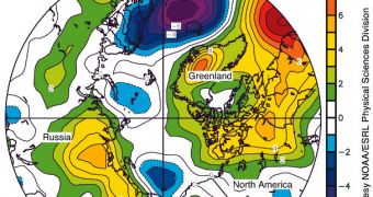
According to the new study, air temperatures in the Arctic remained generally above average last month, while sea ice extents declined at the expected rate. Experts are not very pessimistic however, saying that the total extent of this summer's melt will depend on the weather over the next few months.
If we're lucky, they say, then we'll have a cool summer, that would enable some of the ice which formed last year to endure into the 2012 season. Conversely, if we're unlucky, then all that ice could melt, and then additional chunks, from dwindling, multi-year ice reserves.
“Average ice extent for May 2011 was 12.79 million square kilometers (4.94 million square miles),” the new NSIDC report explains. The Kara, Barents and Labrador Seas were the worst affected.
“This is 210,000 square kilometers (81,000 square miles) above the previous record low for the month, set in May 2004, and 810,000 square kilometers (313,000 square miles) below the average for the reference period of 1979 to 2000,” the document goes on to say.
Areas of open, blacker waters called polynyas continued to develop in the Beaufort, Chukchi, and Laptev Seas. The process began earlier this year, and it's doubtful that it will conclude anytime soon.
Its main effect is destabilizing the ice sheets from underneath, heating the ice packs from their root upwards. This makes it easier for massive glaciers to separate, and then melt into the warm ocean.
According to experts, the more ice melts, the more potent these warm waters become. Their darker colors enable them to absorb more sunlight than surrounding regions, and that heat is then immediately transferred to the ice packs.
“Ice extent during May 2011 declined at an average rate of 50,720 square kilometers (19,580 square miles) per day. That was close to the average decline rate for May 1979 to 2000 of 46,000 square kilometers (18,000 square miles) per day,” the report concludes.

 14 DAY TRIAL //