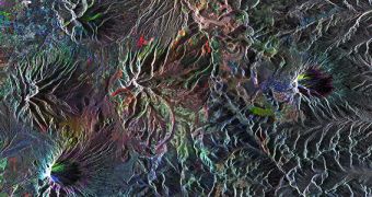
Officials from the European Space Agency (ESA) have just released an archive Envisat image showing the northern highlands of Ecuador at radar frequencies. The photo was taken by the largest commercial satellite ever launched, which ended its primary mission after a decade in Earth's orbit.
The photo shows the northern areas of the Andean Volcanic Belt, a large collection of landscape features produced by the collision between the Nazca and Antarctic tectonic plates. The Antisana volcano, a landmark feature in this collage, can be seen to the center-right side of the photo.
At the top left, Envisat revealed the capital city of Quito, which is one of the highest capitals in the worlds. The city lies at an altitude of 2,850 meters (9,350 feet) above sea level. The massive satellite required three passes to gather enough data for this iconic image.
Interestingly, despite its capabilities, Envisat still produced artifacts in its images. A clear example here are the white glacier-like shapes that seem to adorn all mountain ridges. There are no glaciers on these mountains, at least none that the satellite could detect.
ESA launched Envisat in space on March 1, 2002, aboard an Ariane VG delivery system, from the Kourou Spaceport, in French Guiana, South America. Though it was initially scheduled to spend just 5 years in orbit, last contact was achieved only on April 8, 2012. The spacecraft observed Earth from a geocentric polar low-Earth orbit.

 14 DAY TRIAL //