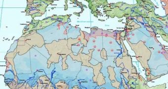
Aquifers are extremely valuable natural resources, especially considering the water shortage that the world will be faced with shortly. These natural formations are just rocks that are able to store huge quantities of fresh water, about 100 times more than all rivers on the surface, at any given time. Because of their high value, they could represent a potential source of conflict for countries that share them. A new map was created to be used as a means of furthering international negotiations on the matter.
Currently, there are two types of aquifers – those that are refueled constantly by rain water infiltrating the soil, and those that store water that fell millions of years ago and are now impervious to other infiltrations. Naturally, the first type constitutes infinite reserves, meaning they could be exploited indefinitely, as long as a sustainable rate of extraction is kept. The second type is a finite resource, in that, once they are depleted of the water they contain, further exploitation becomes impossible.
Thus far, the UNESCO map has revealed some 273 “international” aquifers, meaning, spreading across borders. In the future, when surface water will have become scarcer, these natural resources could prove to be the igniting spark for several international conflicts. UNESCO is currently trying to initiate talks between countries sharing large aquifers, in an attempt to extinguish even the remotest possibility of this happening.
A main priority is to ensure the fair distribution of extracted water to two or three countries sharing such an underground deposit. The geographical factor alone – namely the position of the aquifer layer – is not enough to dictate the distribution of water quantities between the states sharing the resources. Instead, other factors, such as how and where from the aquifers are replenished, what amounts of water each involved country needs and the nation's population numbers, are also to be taken into account when deciding on how to distribute aquifer water.
Up until now, when two countries had to share an aquifer, the most powerful nation received most of the benefits, as was the case with negotiations between the Israeli and the Palestinians, when Israel was granted 90 percent control over four aquifers that spanned both regions. The treaty, signed in 1995, was severely criticized by the Palestinians, who argued that the split was uneven, only taking into account Israel's role in the region.
However, now, sustainability of the reserves has also become an important issue. Hydrologists need to asses the water flows that occur inside these underground deposits, as well as the speed at which rain infiltrates and replenishes them. It's only by knowing this information that international experts will be able to say precisely how much water can be safely extracted, so that the deposits won't be depleted quickly.
The potential conflict that these aquifers could generate also needs to be taken into account by UNESCO, when brokering international treaties. The agreements need to be devised in such a way as to make amends between all parties involved. Preference shown to just one nation could mean that the other, over time, could become desperate and appeal to various means of coercion, such as threats to use weapons, terrorism, or even an all-out war.
Having recognized the importance of settling the international status of these resources, UNESCO is now pushing towards increased numbers of negotiations between nations sharing aquifers underneath their borders. Some 68 of these reserves exist in the Americas, 38 in Africa, 155 in Europe and 12 in Asian countries. All of them will have to be covered by international legislation as soon as possible. To that end, international officials are pushing for the extension of a 1997 United Nations resolutions, concerning "non-navigable freshwater resources."
In regard to the potential impact the newly-devised map might have on involved nations, University College of London hydrogeologist Richard Taylor explains "I do not think that the map in itself has the potential to provoke water conflicts. It would be very difficult for even a very skilled person to say from this map that 40% of a particular aquifer 'belongs' to one country and 60% to its neighbor.”

 14 DAY TRIAL //
