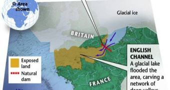
Why does the world have to stand the British insular arrogance? Because of a biblical megaflood that cut the British Isles off from mainland Europe during the Ice Age. 3-D sonar mapping of the English Channel has shown that this must have occurred somewhere between 450,000 and 200,000 years ago.
"It is probably one of the largest floods ever identified," said Phillip Gibbard, a geographer at the University of Cambridge, not involved in this research.
"At its peak, the flood would have discharged water at a rate of about 264 million gallons (a million cubic meters) a second, gushing at speeds of up to 62 miles (100 kilometers) an hour," wrote the researchers.
This means ten times more the entire flow rate of all rivers on Earth.
"In addition to making Britain an island the huge flood had wide-ranging environmental consequences." signaled the researchers.
"For example, the gigantic pulse of freshwater entering the Atlantic Ocean likely caused a period of climate cooling in the Northern Hemisphere. The introduction of ice and freshwater into an ocean drives climate oscillations and causes marked cooling events," said Gibbard.
Animal and plant species on British Isles got isolated, evolving forms which are distinct from their continental counterparts. But this isolation also left the archipelago uninhabited for hundreds of thousands of years.
It was known that just a narrow chalk ridge once connected Dover (southeast England) to Calais (northwest France). During glaciations, when sea levels decreased, the ridge acted like a dam, impeding a huge glacial lake located in the current southern North Sea off the east coast of Britain from flooding a large valley exactly where the English Channel is nowadays.
But during warmer interglacial times, the higher sea levels engulfed the valley and the ridge was the only land bridge. But chalk is extremely friable and river or glacial erosion, tidal scraping, and, what now appears to be a megaflood ended the ridge.
"A 3-D map of part of the English Channel reveals features that could only have been created by a massive flood," signaled the research team.
"We have identified huge scours on the seafloor and streamlined islands. These features are very unusual and have previously been found only in regions where megafloods are known to have occurred." said lead researcher Sanjeev Gupta of Imperial College London.
Similar traits were found in the Channeled Scabland in eastern Washington State, where a massive flood was caused by the glacial Lake Missoula about 12,000 years ago. Probably a small earthquake induced the first few cracks in the chalk ridge-dam.
"Chalk is not very strong, and eventually the water probably just started to over-spill," said Gupta.
The fauna and flora divergence between Britain and mainland Europe times the event between 450,000 and 200,000 years ago, but sediments analysis will tell better.
"There seems to be a large gap in the evidence for human occupation [of Britain] during cold and warm phases from about 180,000 until about 60,000 years ago. When the climate was warm, sea level between the island and the mainland was too high for humans to cross," said Nicholas Ashton, an archaeologist at the British Museum in London.
During frozen ice ages, a land bridge was exposed, but the climate was too harsh for the early humans, which preferred to inhabit milder clime regions in modern-day Italy and Spain.
"It wasn't until 60,000 years ago, that humans-late Neanderthals-had the technological capabilities, such as more effective clothing and shelter, to survive the cold conditions." said Ashton.

 14 DAY TRIAL //