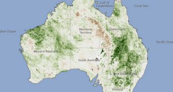
Now here's something you don't see every day, Australia covered in green. Throughout this February, elevated levels of precipitations led to an outburst in vegetation throughout most of the country, but especially in its eastern sector.
A wet summer is to thank for this situation. Usually, conditions on the continent are so dry that most areas remain parched and barren around the year. However, the situation changed a bit over the past three summers, when heavy rains allowed vegetation to thrive.
The image above was taken by the NOAA-18 satellite, which is operated by the US National Oceanic and Atmospheric Administration. The Normalized Difference Vegetation Index (NDVI) data were collected by the AVHRR instrument aboard the spacecraft.
But this situation has a flip side, too. “The greening means we’re going to see a significantly higher risk of wildfire in the same areas in the coming months,” says NASA Goddard Space Flight Center land cover and carbon cycle specialist, James Collatz.

 14 DAY TRIAL //