1. The Andes, this backbone of South America, have a length of 7,600 km (4,800 mi), covering a surface of 2 million square km (800,000 square mi), and having an average height of about 4,000 m (13,000 ft). This is the longest terrestrial mountain range (longer chains are found on the bottom of the oceans).
2. The highest peak of the Andes is Aconcagua (6,962 m / 22,841 ft), in northwestern Argentina. This is the highest mountain in the Americas, and the highest mountain outside Asia, the highest peak in both the Western and Southern Hemispheres.
3. The Andes are made of several parallel chains that unite, from place to place, in orographic knots or depart one from another, forming high plateaus between them, 3,000-4,000 (10,000-13,300 ft) tall. Only in Tierra del Fuego, the Andes crumbles into a multitude of islands and islets.
4. The Andes were the home of one of the greatest civilization in the New World, the Inca Empire.
5. Andes are the result of the head-on collision between two tectonic plates, one (Nazca plate of the Pacific) being driven by subduction areas and buried underneath the South American plate into the Earth's mantle. The collision occurred 50 million years ago. South America is pushed westwards at a rate of 1.5 cm yearly by the mid-Atlantic ridge and at 160 km of its west shore it collides with the Nazca Plate, creating an oceanic trench 8 km deep.
Surprisingly, the researchers discovered that the subduction zones of the largest plates do not retreat but advance, over periods of 5 to 10 million years. In Andes, such advancing areas are those where Bolivia's Andes are located, and where the western edge of South America is convex. The region experiences large compressive stresses due to the westward movement of the South American plate over the Nazca plate in the Pacific Ocean subduction, beginning some 200 million years ago.
Most of the Andes are volcanic mountains (this is common in suduction areas). Ojos del Salado (6,905 m or 23,000 ft) is a volcano located in the Andes on the Argentina-Chile border. It is the highest historically active volcano on earth, located in a remote and very dry region.
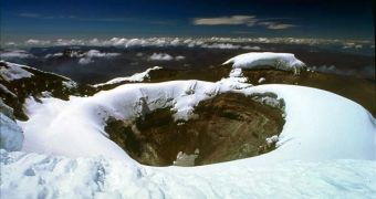
The most famous volcano of South America is Cotopaxi, located in the Andes, about 75 km (50 mi) south of Ecuador's capital, Quito, one of the highest active volcanoes in the world. It is the second highest in Ecuador, after Chimborazo (which is an inactive volcano). Cotopaxi rises from a highland plain of about 3,800 meters (12,500 ft), and has glaciers, even if located on the Equator, starting from 5,000 meters high (16,400 ft). There have been more than 50 eruptions of Cotopaxi since 1738, the last one in 1904.
During a war between the Incas and the Spaniards in 1534, the volcano erupted and put an end to the fighting as both fled from the battlefield. In the 1877, eruption pyroclastic flows descended all sides of the mountain, with lahars traveling more than 100 km into the Pacific Ocean and western Amazon basin, draining the valley. The main danger of a huge eruption of Cotopaxi would be the flow of ice from its glacier and could affect 100,000 people - and another eruption is imminent.
6. The Amazon River is the largest on Earth, eleven times the volume of the Mississippi, and the second longest after the Nile, having a draining area about the size of the United States. Amazon River once flowed westward, opposite to its current direction, from the Atlantic zone to the Pacific, maybe as part of a proto-Congo (Zaire) river system from the interior of present day Africa, when the two continents were bound in the giant supercontinent Gondwana. But the Andes Mountains blocked its flow. The river became a vast inland sea, which gradually plugged, becoming a massive swampy, freshwater lake.
Over 20 species of stingray living today in the Amazon are closely related to those found in the Pacific Ocean and not with those from Atlantic, proving that the river once had contact with the Pacific. 10 million years ago, waters broke the sandstone to the west, allowing the Amazon to flow eastward. During the Ice Age, sea levels decreased and the great Amazon Lake rapidly drained into the Atlantic, becoming a river.
7. You should know that two of the most important crops of the world, potato and tomato, originated both in the Andes Mountains!
8. South America's largest lake is Lake Titicaca, located on the border between Bolivia and Peru. It sits 3,812 m (12,507 ft) above the sea level, making it the highest commercially navigable lake in the world.
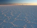
9. In the Bolivian Andes, at a height of 3,650 m (12,160 ft), Salar de Uyuni is located, which is world's largest salt desert: 4,085 square-miles (10,580 square-kilometers), a desert with no sand or dunes. It is the largest salt flat in the world, about 25 times the size of the Bonneville Salt Flats in Utah. Its name comes from Uyuni, the dusty town closest to the desert, while "salar" simply means "salt field" in Spanish.
40,000 years ago, a large salt lake was there, Lake Minchin. Currently, it is a hot spot for adventure tourism. As far as you can see, there are just blindingly white flats, dotted by a few raised salt mounds, in a moon-like landscape. This harsh area was inhabited just by salt miners, who yearly would exploit 25,000 tons of salt from the 10 billion tons deposit. Even if the place looks barren, it is the home of cacti and rare hummingbirds, and three species of flamingos breed here, feeding in nearby salty lagoons. The nearby zones are dominated by bizarre rock formations, geysers with boiling volcanic mud and multicolored salty lagoons. Even inside the desert there are some "oases" with rocks, cacti and shrubs.
In Salar de Uyuni, temperatures can vary from 70? C in the afternoon to below zero at night. You can drive an off roader in Salar de Uyuni, but there are no roads in the wilderness.

 14 DAY TRIAL //
