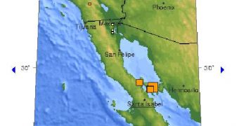
According to the United States Geological Survey (USGS) website, a 6.9-magnitude earthquake occurred on August 3rd at 17:59:56 UTC (01:59:56 pm EDT, 06:59:56 GMT) in California. Located by a precise measurement program as taking place at a depth of ten kilometers (6.2 miles), the tremor's wide effects are still unknown, and the US service is urging all residents in the area to go to its website and post details about how the event was felt in various populated zones around the original epicenter.
“The Gulf of California earthquakes of August 3, 2009, occurred in the plate boundary region between the North America and Pacific plate. At the latitude of the earthquake, the Pacific plate moves northwest with respect to the North America plate at about 45 millimeters/year,” a statement released by the USGS earlier today explains.
It goes on to say that, “The plate boundary beneath the Gulf consists of a series of transform faults separated by small spreading centers or pull-apart basins: earthquakes occur as the result of strike-slip faulting and normal faulting. The seismographically recorded radiation pattern of the main shock of August 3, 18:00 UTC, implies that the shock occurred as the result of strike-slip faulting, but the earthquake has not yet been associated with a specific geologically mapped fault. The largest historically recorded shocks from the Gulf of California have had magnitudes of about 7.”
The epicenter of the tremor was located at 29.066°N, 112.871°W (location established with a seven-kilometer accuracy) and at a fairly safe distance from populated areas in the region.
1. 89 km (56 miles) NNE (31°) from Santa Isabel, Baja California, Mexico 2. 137 km (85 miles) W (280°) from La Doce, Sonora, Mexico 3. 174 km (108 miles) NE (46°) from Guerrero Negro, Baja California Sur, Mexico 4. 185 km (115 miles) W (270°) from Hermosillo, Sonora, Mexico 5. 553 km (343 miles) SE (133°) from Tijuana, Baja California, Mexico
Details of the new earthquake will be posted here as soon as they are available, so keep an eye on this space for more.

 14 DAY TRIAL //