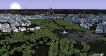
Google has been recreating the world's cities, with the help of volunteer modelers, in 3D. Now it's providing an update for one of the biggest and most famous cities in the world, London, introducing more building and, for the first time, 3D trees in plenty of locations.
In preparation for the royal wedding of Prince William and Catherine Middleton, due next month, Google has updated the models for the entire route of the ceremony's procession.
"With this new 3D data covering the royal procession route, you can indulge yourself in a 'royals'-eye' view to see the same sights that William and Catherine will see," Phil Verney, Program Manager, Google Earth & Maps, wrote.
"Upon departing Westminster Abbey, you’ll pass the Houses of Parliament and Big Ben, the famous ministries on Whitehall and the Prime Minister’s residence at 10 Downing Street," he added.
"Traverse Horse Guards Parade, and from there, you can travel down The Mall—with 3D trees lining the route—and see Buckingham Palace standing proudly at the finish," he continued.
But there's more to London than just the procession's route, plenty of other locations have been recreated in 3D are now available in Google Maps and Google Earth.
A couple of weeks, Google also updated the aerial imagery available in London, providing a much more detailed view of a lot of places in the city.
But it's not just man-made structures that can be viewed in 3D, the update also 'plants' some 12,000 trees in London, in places such as St James' Park, Green Park and Hyde Park. Five different species of trees have been modeled for this region.
Google recently started adding 3D trees after the release of Google Earth 6. Already, there were 80 million trees in Earth, at various locations around the world.

 14 DAY TRIAL //