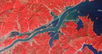
When a magnitude 9.0 earthquake struck the coasts of Japan on March 11, 2011, a massive tsunami followed nearly immediately. In this NASA image, the extent of floods it caused along the course of the Kitakami River is made painfully obvious.
The tsunami struck the northern sector of Honshu worst of all. The island's ria coast, a landscape feature dimpled with bays and coves, was severely affected. The image above shows how one of the rivers in the area looked like just three days after the massive waves struck.
Experts imaged the location using the Advanced Spaceborne Thermal Emission and Reflection Radiometer (ASTER) instrument on the NASA Terra satellite. The image was collected on March 14.
“Wide swaths of flood water cover the north and south banks of the river channel, and sediment fills the river's mouth. Some of the most dramatic flooding occurred just to the south of the river,” NASA says in a statement.

 14 DAY TRIAL //